


rqndo l'orionde

papou73
User
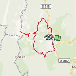

Length
7.3 km

Max alt
1527 m

Uphill gradient
265 m
Km-Effort
10.8 km

Min alt
1292 m

Downhill gradient
265 m
Boucle
Yes
Creation date :
2019-09-06 06:58:52.656
Updated on :
2019-09-06 08:49:52.129
1h48
Difficulty : Very easy

FREE GPS app for hiking
 SityTrail
IGN / Geographical institutes
SityTrail Plus
The world is yours!
About
Trail Walking of 7.3 km to be discovered at Auvergne-Rhône-Alpes, Savoy, Les Déserts. This trail is proposed by papou73.
Positioning
Country:
France
Region :
Auvergne-Rhône-Alpes
Department/Province :
Savoy
Municipality :
Les Déserts
Location:
Unknown
Start:(Dec)
Start:(UTM)
732539 ; 5058562 (31T) N.
Comments